Currently, something more than 800 of the locomotives in our database (and hence on our website) have maps, showing their location, complete with a satellite image. More of these maps are being added daily. So for those of you who haven’t encountered one, I thought I’d write this to explain a little about these maps.
First of all, how do you find these maps? Well there’s a special symbol in the locomotive’s display page that tells you that there’s a map for this particular locomotive. In the image of the 261 display page below, you’ll see a world globe in the upper right. This means that there’s a map available for the locomotive.

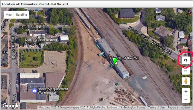
Clicking on the globe in the locomotive display will generate a map display that has a number of features. The display for Milwaukee Road 4-8-4 No. 261 is shown below:

The green marker in the middle of the map points to the location of the locomotive, or to a spot very near to it. In this case the marker points to the entrance door of the building in which 261 is kept, at Harrison Street. There are a number of icons on the map display that do various things. We’ll explain these below:

The zoom control is circled in red on the map above. Clicking on the + symbol will zoom in and on the – symbol will zoom out. You can also control zooming with the wheel control on your computer’s mouse.

The little yellow icon circled in red on the right side of this map is the “Street View” icon. If you click your left mouse button and hold it down while pointing to this icon you can drag it anywhere on the screen, Releasing the mouse button will drop the icon onto the map and the display will change to a street view of the area. When you drag the Street View icon you’ll see blue lines appear on the roads in your map. These lines signify where the Steet View photographic car drove. If you drop the icon on one of these blue lines you’ll get excellent images from street level.

The image above was created by dragging the Street View icon onto the map at Spring Street. You can return to the overhead view of the locomotive location by clicking on the left pointing arrow in the upper left corner of the image.

In this view the “Overhead” icon is circled. If you look at the image above we’re looking at the 261 engine house at an angle from the south. Clicking the overhead icon will give you a view looking straight down from above the marker. Clicking it again will return to this view. This icon doesn’t always appear. It’s only there if Google Maps has the necessary information to do the display. Here’s what the overhead view looks like:

In the image below, the “Rotate” icon is circled. If this icon appears then Google Maps has the information to show you a very interesting view of the location. Each time you click the Rotate icon the map will rotate 90 degrees. I hope this basic information has proved useful. Any questions about this feature can be directed to info@steamlocomotive.info.
Regards,
Doug
